Where Biodiversity, Climate Risk, and Urban Growth Collide
By Jared Brey
Among the various transformations taking place on Planet Earth are the distinct but overlapping crises of anthropogenic climate change, mass extinction of plants and animals, and the steady expansion of urbanized space. Scientists and planners know these phenomena to be interrelated, yet to date, little work has been done to understand how these crises intersect in specific places.
A new project led by researchers at The Ian L. McHarg Center for Urbanism and Ecology, in partnership with UN-Habitat and One Architecture & Urbanism, aims to highlight points of conflict between climate risks, biodiversity, and urban growth in a few of the world’s poorest cities—with the goal of helping local leaders plan safer futures for their human and non-human inhabitants.
The project is led by McHarg Center Fellow for Risk and Resilience Matthijs Bouw, who is also a professor of practice in landscape architecture at Weitzman, and Co-Executive Director Richard Weller, professor and chair of landscape architecture and Meyerson Chair of Urbanism. Weller has spent years studying conflicts between biodiversity and urban growth through the Hotspot Cities Project and other research. Bouw, the founder of One Architecture & Urbanism, co-authored the new book “Managing the Climate Crisis, Designing and Building for Floods, Heat, Drought, and Wildfire” with Professor of Practice Emeritus in City and Regional Planning Jonathan Barnett.
Along with a team of Weitzman students, Bouw and Weller were engaged by Andrew Rudd, urban environment officer for UN-Habitat’s Programme Development Branch. Too often, designers and planners have tended to “treat environmental issues as an optional filter or a kind of flavor, rather than as something integral and necessary” to their project, Rudd says. Rudd met Weller through his project Atlas for the End of the World, and later spoke at a 2019 Hotspot Cities Symposium at Penn. He says he wanted to take Weller’s approach—of mapping the collisions between urban growth and sensitive, biologically rich environments—and put it to use in specific areas of need.
“The way he’s able to pinpoint where conflict was, I wanted to see that taken further and prompt real action on the ground,” Rudd says.
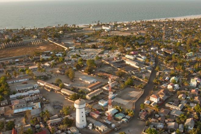
The project focused on three cities: Morondava, Madagascar; Lilongwe, the capital city of Malawi; and Honiara, capital of the Solomon Islands. The cities were selected in consultation with the Swedish International Development Cooperation Agency, which largely funded the project, according to Rudd. Researchers compiled various datasets to identify areas where urban growth, including informal developments at the edges of the cities, threatens to damage areas of high biodiversity. They also identified conflicts between urban expansion and increasing risks from climate change, between biodiversity and climate risks, and between all three.
Identifying those conflict zones should help local officials plan to minimize conflicts, protecting vulnerable species and directing human settlements away from areas at high risk for climate disasters, Weller says. It will also help those cities keep up with long-range commitments made as signatories to the Convention on Biological Diversity.
“It can be used as a tool to affect urban planning decisions and prioritize the conservation dollar and land-use plans as cities are rapidly growing in these parts of the world where they don’t usually receive a lot of design and planning intelligence,” Weller says. “What we’ve given them is a sort of first step to producing whole-of-city plans out towards 2050.”
It was a goal of the project to provide useful tools for communities in Lilongwe, Honiara and Morondova. But it was also important to create a process for identifying conflict areas that could be repeated in other places, Bouw says.
“There are many cities with that will have between 100,000 and 1 million inhabitants by 2050 that are in these hotspot areas,” Bouw says. “So it’s really important to have a method that’s applicable. And that’s also the objective of the UN—to see how they can replicate this method for other cities, thousands of other cities that could benefit from this understanding.”
The maps are built using relatively coarse datasets, and the researchers are careful to point out that they need to be “ground-truthed” by local residents and planners. Oliver Atwood, a Master Landscape Architecture student who worked on the project, says it was a challenge to find ways to visualize conflicts between biodiversity, climate risk, and urban growth, and “to have them be graphically distinct from one another in a way that was legible.” Atwood applied to Penn partly because of Weller’s Hotspot Cities work, and he notes that the project shares lineage with the methods pioneered by Ian McHarg when he was chair of the Landscape Architecture department at Penn.
“It’s like the latest manifestation of the McHargian approach, but more complex in its conception and nuanced in its presentation,” Atwood says.
Landscape Architecture student Bhoomi Suresh Shah also worked on the project, along with Ce Mo (MLA’19), now a landscape designer at Bouw’s firm. The maps and data that the group compiled are being presented to local officials in Lilongwe, Honiara, and Morondava. And the team is preparing a white paper outlining the method it developed, so other cities can make use of it.
Mapping has been used throughout history as a tool of colonial conquest and dispossession, Atwood says. But he hopes projects like this one can do the opposite.
“My hope is that through these kind of mapping methods, people who live in these places can be further empowered to manage their own landscapes,” Atwood says.